Wi-Fi surveying is normally performed by walking around a building with a laptop, smartphone, or dedicated spectrum analyzer. But what happens when you combine wireless surveying with a drone?
A drone carrying a lightweight Wi-Fi sensor can become an interesting platform for studying how 2.4 GHz, 5 GHz, and potentially 6 GHz wireless signals propagate through a neighborhood or other authorized test area. The resulting data can be used to visualize coverage, identify channel congestion, study interference, and understand how surprisingly far Wi-Fi signals can travel.
The important distinction is that this project is about passive observation—not accessing other people’s networks.
Building the Drone Wi-Fi Survey Platform
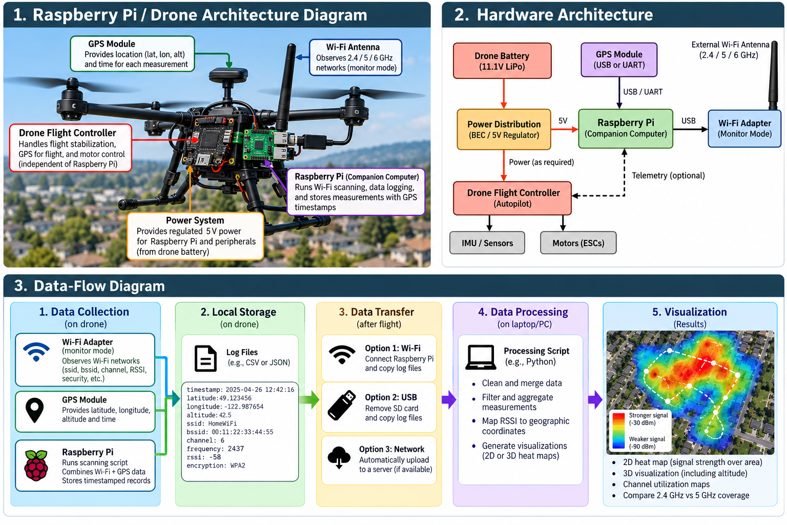
The drone itself does not necessarily need to perform the wireless analysis. Instead, it can carry a small companion computer.
A typical experimental setup could include:
Drone → Companion computer → Wi-Fi adapter → GPS → Logging software
A lightweight Linux computer such as a Raspberry Pi can serve as the data-collection system. A compatible Wi-Fi adapter can observe wireless management traffic while GPS coordinates provide geographic context.
The drone’s normal flight controller remains responsible for flying the aircraft. The companion system independently records wireless observations.
An important engineering consideration is weight. Every additional component affects flight time, balance, power consumption, and potentially radio interference.
What Can Be Observed?
Wi-Fi access points periodically transmit management information that allows nearby devices to discover wireless networks.
A passive survey can record information such as:
- SSID, when the network name is publicly advertised
- BSSID or access-point identifier
- Wi-Fi channel
- Frequency band
- Signal strength (RSSI)
- Advertised security mode
- Supported wireless capabilities
- Observation time
- GPS coordinates of the measurement
You don’t need to authenticate with the network to perform this type of radio survey.
More importantly, discovering a Wi-Fi network does not mean that you have permission to connect to it, capture private communications, defeat its security, or attempt to determine its password.
Monitor Mode and Wireless Observation
For research conducted on networks and equipment you own or have permission to test, Linux wireless adapters that support monitor mode are particularly useful.
Monitor mode allows an adapter to observe compatible 802.11 radio frames rather than behaving solely as a conventional Wi-Fi client.
Common wireless-analysis platforms include Wireshark, Kismet, and Linux wireless utilities.
For a drone experiment, a particularly useful architecture is to have the companion computer continuously generate records resembling:
Timestamp | GPS | BSSID | SSID | Channel | RSSI | Security
For example:
12:42:16 | 49.x,-122.x | AP-01 | TestLab | 6 | -58 dBm | WPA3
The coordinates above should represent where the measurement was taken, not necessarily the actual location of the access point.
Creating a Wi-Fi Heat Map
This is where the project becomes especially interesting.
Imagine flying several predetermined paths across your own property or another area where surveying is authorized. The sensor records the received signal strength of your test access point every few seconds.
After the flight, the measurements can be imported into Python, GIS software, or another visualization platform.
The result could look conceptually like:
Drone flight path
↓
GPS + Wi-Fi observations
↓
Timestamp synchronization
↓
RSSI measurements
↓
Geospatial database
↓
Wireless coverage heat map
Instead of simply discovering that an access point exists, you can visualize how its signal changes with altitude and distance.
A More Interesting Experiment: 3D Wi-Fi Mapping
A drone offers something that conventional Wi-Fi surveying does not easily provide: altitude.
Record latitude, longitude, altitude, and RSSI together:
Latitude | Longitude | Altitude | Channel | RSSI
You can then investigate questions such as:
How quickly does a Wi-Fi signal weaken vertically?
Does a second-floor access point produce stronger measurements at certain drone altitudes?
How do buildings, trees, roofs, and other obstacles affect propagation?
Does 2.4 GHz remain detectable farther away than 5 GHz?
The measurements could eventually be transformed into a three-dimensional RF coverage model.
Detecting Channel Congestion
The same platform can also study spectrum utilization.
In a typical residential area, numerous access points may compete for a relatively small amount of spectrum. A passive survey can count observed access points by channel and compare their relative signal strengths.
For example:
| Channel | APs Observed | Strongest RSSI |
|---|---|---|
| 1 | 8 | -51 dBm |
| 6 | 17 | -43 dBm |
| 11 | 6 | -61 dBm |
This information can help you understand interference affecting your own network and select more appropriate channels where manual channel selection is supported.
Security Lessons from the Experiment
Aerial Wi-Fi surveying demonstrates an important cybersecurity principle:
Radio signals do not stop at your property line.
A wireless network intended for a home may remain detectable from the street, neighboring properties, or from above.
Home users should therefore rely on strong security rather than assuming physical distance provides protection.
Use WPA3 when supported, or WPA2-AES for older equipment. Choose a strong, unique Wi-Fi passphrase, disable WPS when it isn’t needed, keep router firmware updated, and place untrusted IoT equipment on an isolated network or VLAN where possible.
Network names should also avoid unnecessarily revealing personal information such as a resident’s name, apartment number, or address.
Keep the Experiment Passive
There is an important technical and ethical boundary between wireless surveying and wireless intrusion.
A drone-based research project can examine signal strength, channels, frequency utilization, coverage, and publicly advertised wireless characteristics.
It should not be used to attempt authentication against neighboring networks, obtain passwords, bypass encryption, disrupt access points, impersonate legitimate infrastructure, or access systems without authorization.
If you want to experiment with offensive Wi-Fi security techniques, build a controlled lab using access points and client devices that you own. That gives you a safe environment for studying authentication, packet analysis, wireless attacks, detection, and defensive monitoring without targeting somebody else’s network.
Conclusion
Combining drones, Linux, GPS, Wi-Fi sensing, and geospatial visualization creates a fascinating cybersecurity and RF engineering project.
A relatively simple drone-mounted sensor can transform individual Wi-Fi observations into a geographic dataset showing how wireless signals propagate through three-dimensional space.
The most interesting result isn’t discovering how many networks are nearby. It’s understanding how radio signals behave outside the environments in which we assume they are contained.
That makes drone-assisted Wi-Fi surveying useful not only as a hobby project, but also as an introduction to wireless security, RF propagation, spectrum analysis, geospatial analytics, and defensive network engineering.